Plans for a new bridge south of Crewe station aimed at easing congestion in Nantwich Road have been adopted by Cheshire East Council, writes Stephen Topping.
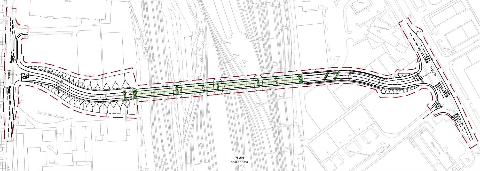
Cabinet members approved a preferred route for the new Southern Link Road Bridge at a meeting this week, following consultation held over the summer.
The new bridge would be built from Gresty Road to the west – north of the St Clair Street junction – to Weston Road on the east, close to Cowley Way.
CEC will now work on a business case for the bridge ready to submit to Government for future funding opportunities.
Cllr Brian Roberts, Labour member for Crewe West and cabinet member for highways and waste, said: “There are mixed feelings from the general public about the bridge.
“But I see this bridge as being a catalyst to reduce the never-ending growing congestion that we experience in the Nantwich Road area.
“I don’t want to miss an opportunity in that area being regenerated.
“It’s in real dire need for a total rethink of the area.”
However, Cllr Roberts admitted he did have concerns congestion could be shifted from Nantwich Road to the residential area around the bridge – and he called on CEC to use the plans as part of a “green corridor” into town, similar to Jack Mills Way.
There was a mixed reaction to the bridge in public consultation – with 86 respondents agreeing with the need for a bridge, and 53 suggesting they are against it.
Royal Mail objected to all options for the bridge, with the eastern side of it set to be close to the sorting office in Weston Road.
Concerns about “rat running” around the bridge were also raised in the consultation.
But Cllr Craig Browne, CEC’s independent deputy leader, said that traffic calming measures would be put in place to mitigate those issues.
Cllr Janet Clowes, leader of CEC’s Conservative opposition, said: “I think that on balance the recommended option that has come forward is the right one for this particular project at this particular part of Crewe.
“I think we have to look at it as an essential jigsaw piece in the larger puzzle that is being assembled and has been assembled for several years now.”
The bridge would include a footpath and cycleway, while junction improvements around the bridge would also be designed to cut congestion.
As well as prepare for funding opportunities, CEC will now be able to enter into legal agreements with Network Rail for the scheme and begin discussions with affected landowners, residents, businesses and community groups.
The remainder of the Crewe Hub area action plan – which prepares south Crewe for regeneration ahead of HS2 – is set to be adopted by cabinet at a future meeting.


The decision had already been taken before the so called consultation took place at the Alex football ground. The Cheshire East questionnaire had no objection section of the comments form only favourable options. The various organisations had no idea what was going to happen in the resdentenial areas opposite the bridge which is used as a free parking area for commuter’s and football fans. The roads are already a rat run which it is now. Families who can afford it are moving out due to Cheshire East council allowing get rich quick landlords turning terraced family homes into HMOs. As a resident of At Clair Street which is now a rubbish stroon rat infested ghetto. If one of these officials would swop homes with me I would be grateful.
Why is the bridge going straight through the middle of Crewe Alexandra’s car park?
On match days the residential area’s will be even more congested than they currently are! Cheshire East is this the best plan you can come up with? Maybe concentrate and put all efforts into rejuvenating Crewe town centre? Cheshire East always good at wasting money rather than spending it where it needs to be spent.#JOKERS#
Best way is to make it one way passed the station then down Mill street or EdlestonRoad passed Tesco then over one way back to Macon way or even as far as Hungerford. People will get used to it. Cheaper than a bridge too far!!
Why is a bridge being put where it is not required?
The problem arises outside the station on Nantwich Road.
The best solution would be a fly-over to take the A534 over the station roundabout and put station access under Nantwich Road and stop pedestrians crossing the A534 so pedestrian crossings and traffic lights would not stop traffic and block the station roundabout.
Certainly 1 set of traffic lights and 2 crossings all in close proximity and not synchronised is simply daft.